Geospatial Operations hos Tiepoint refererer til hele spekteret av dronebaserte datainnsamlings- og analysetjenester - fra kartlegging og oppmåling til strukturell inspeksjon, terrengmodellering og AI-drevet innsiktsgenerering. Hver kunde og hvert oppdrag er unikt, og tjenestene våre skreddersys deretter. Enten du trenger en komplett totalløsning eller bare én komponent, skalerer og tilpasser vi oss dine operative krav.
Denne siden gir en oversikt over funksjonene som er tilgjengelige gjennom vårt Geospatial Operations-tilbud - et modulært sett med verktøy og arbeidsflyter som er utviklet for å hjelpe deg med å innhente, analysere og handle på grunnlag av romlige data på en trygg måte.
Dronebasert kartlegging og oppmåling
Vi tilbyr kartlegging og oppmåling fra luften med høy presisjon ved hjelp av elektriske droner utstyrt med RGB-, termiske, multispektrale og LIDAR-sensorer. Plattformene våre er i stand til å fange opp store og komplekse miljøer med nøyaktighet og repeterbarhet - fra byutvikling og kystlinjer til offshore-infrastruktur og avsidesliggende terreng.
Vi støtter generering av ortofoto, terrengmodellering, høydeprofilering og volumanalyse, og tilbyr et raskt og miljøvennlig alternativ til tradisjonelle oppmålingsmetoder. Enten du jobber med infrastrukturplanlegging, stedsovervåking eller miljøvurdering, kan dronene våre hjelpe deg med å dekke et større område på kortere tid.
Inspeksjon av infrastruktur med drone
Inspeksjonstjenestene våre er skreddersydd for kunder som har behov for å overvåke tilstanden til infrastruktur på en sikker og effektiv måte. Ved hjelp av stabiliserte kameraplattformer og høyoppløselige sensorer kan dronene våre utføre inspeksjoner på nært hold av broer, bygninger, tårn, rørledninger, vindturbiner og mye mer - selv i utfordrende eller farlige miljøer.
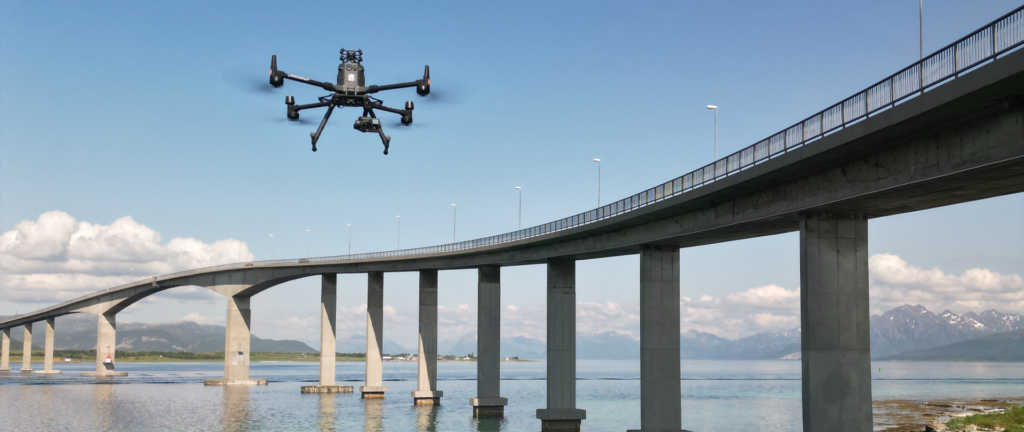
Vi tilbyr også automatisert feildeteksjon ved hjelp av kunstig intelligens, noe som bidrar til å identifisere strukturelle risikoer som korrosjon, feiljustering og slitasje. Alle inspeksjonsdata behandles i rapporter som kan brukes til forebyggende vedlikehold, samsvarskontroller og sikkerhetssikring.
Miljøovervåking og landskapsmodellering
Miljøbevissthet er en økende prioritet i mange av sektorene vi betjener. Dronesystemene våre brukes til å kartlegge kystlinjer, våtmarker, skoger, offshoresoner og andre naturlandskap - noe som gjør det mulig å oppdage erosjon, vegetasjonsendringer, forurensning eller utslipp på et tidlig tidspunkt.
I miljøberedskapsscenarioer, som for eksempel oljevernberedskap, leverer vi romlige data i sanntid som støtter både planlegging og direkte operasjoner. Våre stillegående, elektriske droner forstyrrer miljøet minimalt, noe som gjør dem ideelle for beskyttede områder og sensitive økosystemer.
3D-modellering og visualisering
Vi lager svært nøyaktige og oppslukende 3D-modeller av terreng, infrastruktur, bygninger og industrianlegg. Disse modellene kan brukes til måling, designplanlegging, presentasjoner for interessenter og integrering med digitale tvillingmiljøer.
3D-resultatene våre er kompatible med BIM-, CAD-, GIS- og VR/AR-plattformer, og hjelper deg med å gå fra rådata til interaktiv innsikt. Enten du skal administrere en byggeplass, bevare et kulturminne eller evaluere et fremtidig prosjektområde, gjør 3D-modelleringstjenestene våre dataene dine håndgripelige og utforskbare.
AI-drevet databehandling
Bak ethvert vellykket oppdrag ligger en robust datapipeline. Vårt interne prosesseringsteam kombinerer tradisjonell geospatial analyse med maskinlæringsverktøy for å hente ut informasjonen du trenger fra dronedata raskt og pålitelig.
Vi tilbyr blant annet objektdeteksjon, merking av eiendeler, automatisering av målinger og endringsdeteksjon. Våre AI-modeller bidrar til å redusere behandlingstiden, øke konsistensen og avdekke skjulte mønstre som ellers kan bli oversett i komplekse datasett.
Bærekraftig flyteknologi
Alle våre operasjoner utføres ved hjelp av elektriske droner. Dette gjør at vi kan levere profesjonelle lufttjenester uten bruk av drivstoff og nesten lydløs drift - noe som er spesielt viktig i urbane miljøer, naturreservater eller offshore-plattformer.
Ved å erstatte helikopteroverflygninger, båtbaserte oppmålinger og inspeksjoner av store kjøretøy med lette luftsystemer hjelper vi kundene våre med å redusere karbonavtrykket, samtidig som vi øker fleksibiliteten og reduserer den operasjonelle risikoen.
Skreddersydd til ditt oppdrag
Geospatial Operations er ikke et fast produkt - det er et rammeverk. Kundene våre spenner fra infrastrukturutviklere og nødetater til offentlige etater og frivillige miljøorganisasjoner. Noen ber om en 3D-modell for én gang, mens andre trenger kontinuerlig kystovervåking. Vi tilpasser oss begge deler.
Uansett hvor stort eller komplekst prosjektet ditt er, hjelper teamet vårt deg med å utforme en dronebasert arbeidsflyt som leverer akkurat det du trenger - enten det er rådata, bearbeidede bilder eller fullstendig analytisk rapportering. Vi setter vår ære i å gjøre romlig innsikt tilgjengelig, bærekraftig og pålitelig.
Jobb med Tiepoint
Er du klar til å utforske hva Geospatial Operations kan bety for teamet ditt? Ta kontakt med Tiepoint for å starte en samtale om dine behov, så hjelper vi deg med å bygge en løsning som passer - fra en enkelt undersøkelsesflyvning til en fullt integrert operativ pipeline.

Du er eksperten
- la oss støtte deg og gi deg rom til å gjøre det du kan best
Er du en ingeniør, utrykningspersonell, bygg-inspektør eller fotograf? Opplever du å undergrave ekspertisen din av å bli overbelastet med nye droneregler, prosedyrer og utvikling?
Gjennom vår drone-støtte vil vi navigere gjennom dette minefeltet og få deg i luften på en trygg og lovlig måte
- Vi tilbyr deg med kunnskapen og sikkerheten du trenger, slik at du kan fokusere på arbeidet og flyvingen.
- Vi utvikler prosedyrer og nødvendig dokumentasjon etter dine krav.
- Vi tilbyr utdanning og trening.
- Vi leverer drone-støtte og systemer for sikkerhets-håndtering.
Drone-støtte
Sikkerhet og kunnskap til deg!