Real World Deployment of ESA’s AI-Driven Crisis Response System
The ESA driven Civil Security from Space (CSS) project, focusing on how satellite- and drone-data can support first responders with valuable data insight, got an unexpected head start when a large cargo ship ran aground near Bryneset outside of Trondheim on May 23. Public safety officials started raising concerns about slope instability and potential hazards, as the ship had struck ground in a residential area.
The incident perfectly illustrates why combining space-borne observation with rapid, on-scene drone mapping is so valuable. Tiepoint’s ESA CSS system was ready to provide time critical intelligence to the Civil Security sector, as a quadcopter, due to the closeness to a first responder drone team, was deployed by Mid-Norway Fire Dispatch Center to capture high-resolution imagery.
The mapping mission aimed to give local authorities the situational awareness needed for both immediate response and long-term planning. Those models are now being used to monitor ground movements and evaluate ongoing risks in the area, helping authorities assess, evaluate and monitor risks connected to a potential landslide in the region.
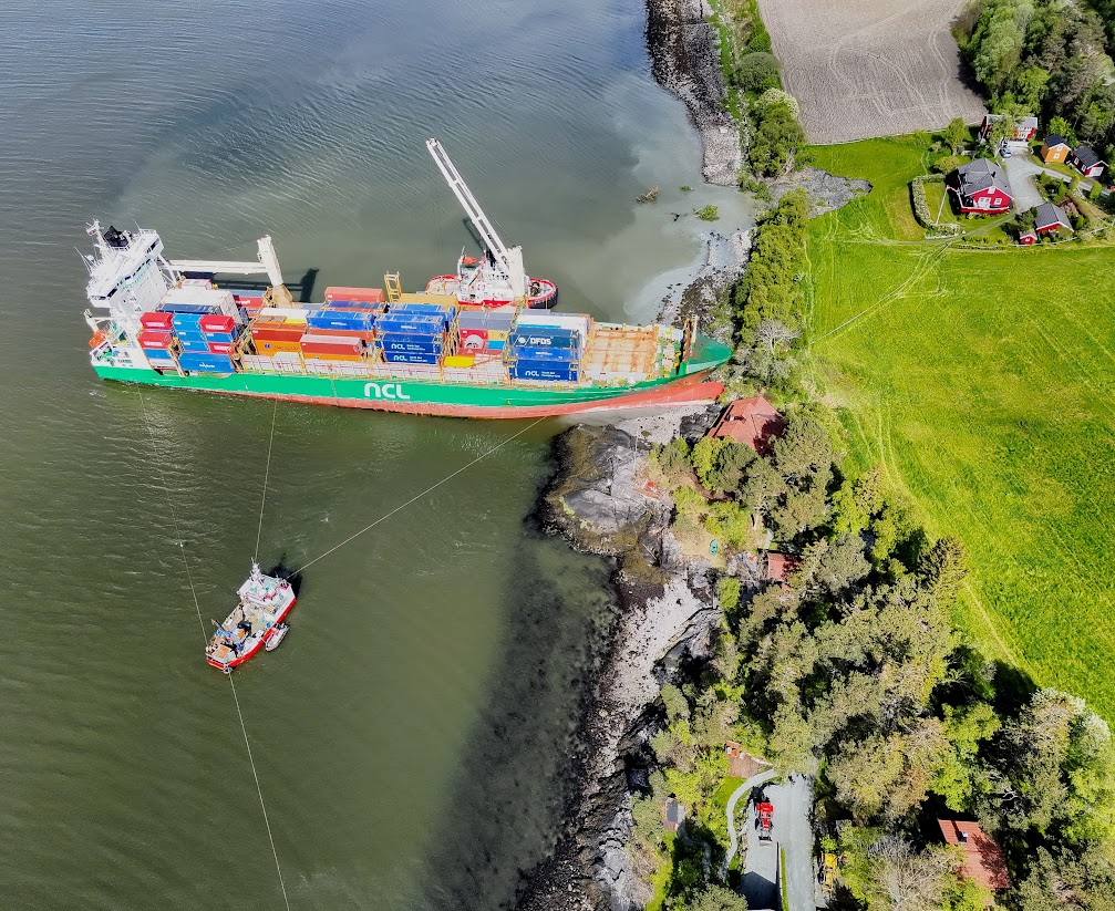
Rescue vessels working on the grounded vessel.
Image: Mid-Norway Fire Dispatch Centre
Landslide Concerns
Shortly after the vessel struck ground, a minor landslide was observed near the ship. With several residential homes located close to the incident site, emergency services flagged the risk of further slope movement. Authorities needed a clear view of the terrain to make decisions about evacuation zones, slope reinforcement, and restrictions towards public access. The drone-based mapping gave them fast and reliable data to work with.
During an event like this, accurate and up-to-date aerial data is a vital resource. Drones provide a safe and efficient way to gather aerial imagery, and the crucial data for generating digital terrain models of potential hazards. Compared to satellite data or a manual inspection, drones can deliver faster results with high resolution and fidelity, allowing for real-time decision making in dynamic environments.
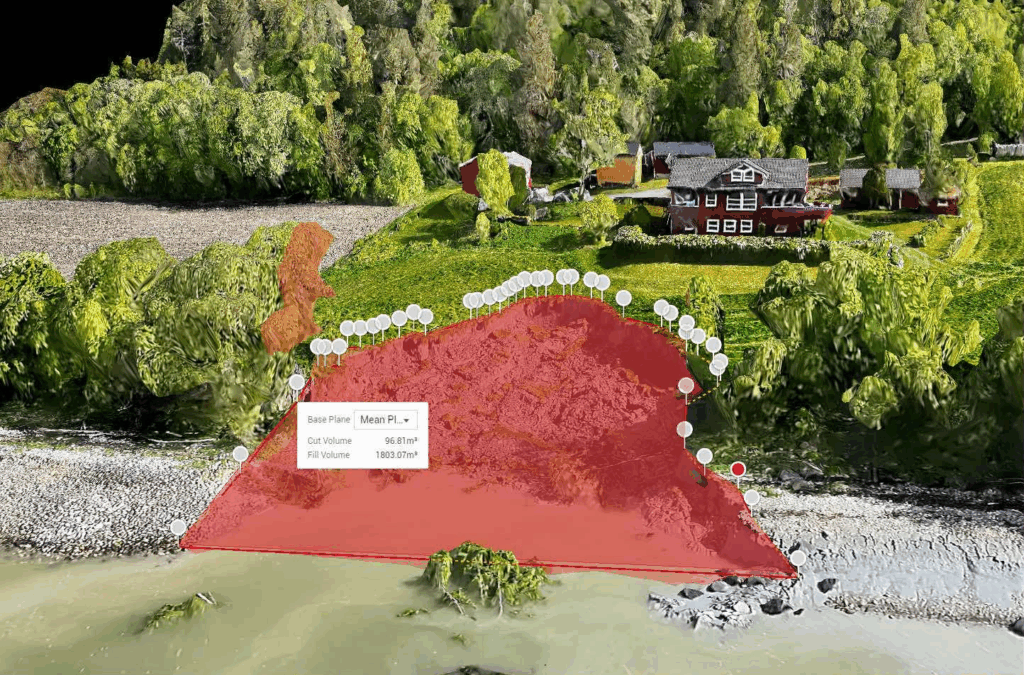
Image: Mid-Norway Fire Dispatch Centre
Why Aerial Data Matters and When Satellite Data Becomes Critical
The grounding of the Northguider (full story here) in December 2018, deep inside the Hinlopen Strait of Svalbard, serves as a textbook example of why satellite data is indispensable in remote and inaccessible areas. With severe Arctic weather, extreme remoteness, minimal daylight and fragile communication infrastructure, deploying drones in time simply wasn’t feasible. In contrast, satellite imagery was available almost immediately and became a critical source of information during the emergency.
These satellite images were acquired through the capabilities of KSAT(https://www.ksat.no/). They were used to monitor ice coverage, assess environmental risks and support logistical planning for any potential rescue or salvage operations.
This case highlights a key strength of the ESA Civil Security from Space (CSS) programme: the ability to rapidly task satellites over remote regions when time-critical information is needed. Satellite data bridges the gap when drones are out of reach. This can be due to geographic limitations or timing. It also provides persistent, wide-area situational awareness from space.
In contrast, during the Trondheim grounding, trained drone crews were located close by and managed to deliver high-resolution models within hours. Here, the drones were optimal for detailed terrain mapping, while satellite passes offered valuable daily updates to monitor gradual changes, detect new terrain movements, and expand the overview to surrounding areas.
Together, these technologies form a complementary aerial ecosystem: satellites for rapid, broad-scale and remote access, and drones for ultra-high-resolution, tactical insight on demand. In future ESA-supported operations, integrating both the space-based and drone-based layers will ensure faster, more informed responses, regardless of the environment.
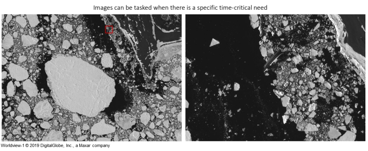
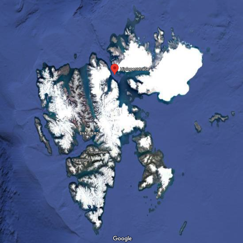

Image: Kystvakta / Kystverket
Tiepoint’s Contribution
This mission is part of Tiepoint’s broader support for emergency services and public authorities. This work also aligns closely with Tiepoint’s ongoing project with the European Space Agency (ESA) under the Civil Security from Space Programme.
The incidents mentioned above are only a couple, amongst many, that highlight the real-world need for the ESA-funded “AI-Driven Crisis Response System” and how the project will propel public safety towards the future. Through this initiative, Tiepoint aims to enhance emergency response by performing real-time fusion of drone- and satellite-data supported by AI.
Whether using drones or satellites, the goal remains the same: getting the right data to the right people, as fast and safely as possible. Both approaches are part of a broader vision using aerial technology to support decision-making when time and terrain are working against responders.
Key technologies for this project include the development of AI for Satellite and drones, edge-AI for drones – for offline capabilities, human-in-the-loop validation, and continuous model training. This development allows authorities to detect anomalies faster, assess risks more accurately and act decisively.
These scenarios with grounded vessels are a clear example of how timely aerial data can support emergency response today, while the ESA project points toward how these responses can be even more intelligent, integrated and scalable tomorrow.